The National Weather Service (SNM) in San Juan reported this morning that the bouts of rain and wind that were felt in the island sectors, and associated with the passage of a strong tropical wave, will continue until today, Saturday.
The rain will continue into Sunday, with weather conditions expected to gradually improve later in the day, meteorologist Emmanuel Rodriguez of SNM’s San Juan offices said.
Sea conditions will remain hazardous on Saturday and Sunday, so extreme caution is recommended on beaches and coasts.
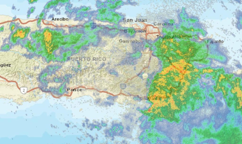
“We have a fairly strong tropical wave moving over the area, and this system since early morning has started moving groups of torrential rain and thunderstorms over the eastern and southeastern municipalities and the urban area, leaving bouts of occasional torrential rain,” Rodriguez explained.
“Currently, the heaviest rain fell in the southern part of the capital region, where radar estimates range between an inch and an inch and a half,” he added.
It also left winds in the gusts of very strong winds. Here in San Juan, or at Carolina Airport (Luis Muñoz Marine International), winds of 45 mph were reported, Ciba reported, 40 mph, Culebrita Island, in Culebra, it was 47 mph” .
“The reality of the case is that storm rain bands should last all day. The whole island should receive winds. But the east and southeast should see the largest accumulations of rain with this system, today we can talk about three inches (of rain) or up to Four inches in some sectors,” he explained.
For Sunday, as the wave moves over the region, rain is still expected across the country, albeit less severe. To the extent that cloud cover is generally less, local impacts can generate more rain over the interior and western regions, which may be heavier, “but these sectors are already used to seeing these amounts of rain and should not have a greater impact.”
The expert noted that with regard to the possible effects of the tropical wave, “the wind worries us a little, because it can cut some tree branches and old trees and disrupt traffic in some sectors.”
“For heavy rain, because the land was dry with this drought that we have seen, but in any case, bouts of heavy rain can always cause floods in urban centers or poorly drained sectors if the rains continue for a long time.”
But for now, there are no reports of damage.
On the other hand, considering that we are into a long weekend with the 4th of July holiday, and that many people usually go to celebrate on the beaches, the meteorologist warned that sea conditions would be dangerous across the island.
“Today (Saturday) and tomorrow (Sunday), with bad conditions at sea, we will have a high risk of sea currents. It will be all over the island, a little less to the west, but the whole island will be at high risk of currents,” he explained.
He added that the sea will remain “rotty,” and in fact, there is a warning in effect for small boat operators, which both fishermen and people who go out to sea in boats should heed.
For Monday, the sea is already expected to be “a little better, but not quite better. So, if you are going to the beaches, you still have to be careful, especially on those more exposed coasts, where there is a danger of currents, especially in the north.” The sea “will still be rough, although not as dangerous, but in any case caution should be exercised”, especially in the north, which is a much more dangerous area.
The expert recommended residents to monitor SNM’s weather bulletins and reports, especially those who live in flood-prone areas “to be alert for any sign of possible flooding in their communities.”

“Music buff. Social media lover. Web specialist. Analyst. Organizer. Travel trailblazer.”

:quality(85)/cloudfront-us-east-1.images.arcpublishing.com/infobae/TEQF6EONZRFGLLLDIDD4L2O4EE.jpg)

:quality(75)/cloudfront-us-east-1.images.arcpublishing.com/elcomercio/XU32LRAEZFDDPNVHLFU3CKVBYY.jpg)


More Stories
Sheinbaum, Galvez, Mainz campaign wrap-up, news and more
Sheinbaum and Mainz’s CDMX campaign wraps up: Road Alternatives and Street Closures
Ortega attacks Humberto Ortega and declares him a “traitor to the country”